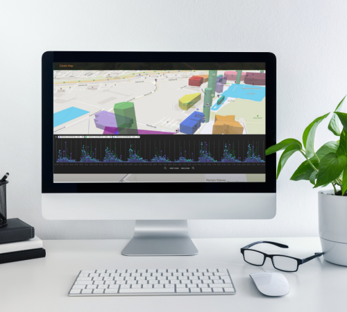
With a variety of charts, tables and graphs to tell your data story Active Maps can help you visualise even the most complex data sets and showcase them in a way that’s easily digestible for everyone.
You don’t need to be a GIS expert or developer to use Active Maps. The user-friendly interface allows you to pick and choose data and visualise it in 3D with geographic context in just a few clicks.
unlimited logins
Sharing and collaborating with Active Maps couldn’t be easier, create as many logins for colleagues and team members as required. Manage access levels and use the platform dashboards to share your data stories.
Historic Data Changes
Active maps gives you the ability to show time series data. Whether it’s footfall heatmaps, rainfall radar or vehicle counts the 3D map of your estate will dynamically change as you move through time, allowing you to tell your data story beautifully.
ALERTS & NOTIFICATIONS
Your Active Maps data stream from your proprietary software and systems is always running, this means you can set up alerts and be notified of data spikes in real-time. So if noise sensors suddenly peak or an accident causes congestion in your smart city you’ll know about it instantly.
narrating your data story has never been easier
At Active Maps we're simplifying the world of data, giving our clients the tools to visualise their data and share it in easy to understand ways. Data related to a location or place is best shown in context, with our 3D map layers you can show detailed visualisations that express change and relationships of combined geo-spatial data. From footfall and noise pollution data to warehousing stock levels or arrivals and departures at busy ports our Active Maps tools makes everything visible at the touch of a button.
our clients
Dr Peter D. Hunter
Forth-ERA Science Director & Associate Professor of Earth Observation Scotland's International Environment Centre
The Forth-ERA projectis the primary force in Scotland’s bid to become a net-zero society, in developing a detailed understanding and analysis of the Firth of Forth we’re creating programmes that use nature toreverse climate change impact in our ecosystems and environment
Dr Peter D. Hunter
Forth-ERA Science Director & Associate Professor of Earth Observation Scotland's International Environment Centre
The team at 3DEO are experts in their field, working with us as experts in ours, we’ve developed a cutting edge digital estate for the Firth of Forth and become an exemplar for digital water in the process, the ability to visualise climate programme results on our Active Maps dashboard allows our successes to be easily digested by a wide target audience.
book your free demo
Choose to find out more about exactly how Active Maps can benefit your business with a no obligation 30 minute online demonstration tailored to your needs. Book a time and date that suits you below.