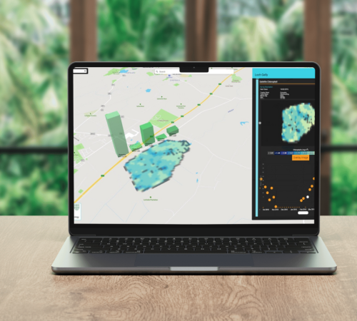
Data spending too long locked in proprietary software or sitting on someone’s desk? Stream your data to Active Maps for instant, real-time visualisation and reporting.
Once our tech team have set up your data points any new data from sensors, software or IoT devices streaming to Active Maps will automatically appear. All of your important data shown in a single view for you to combine and analyse.
real-time data , alerts & notifications
Because data is pulled into Active Maps in real-time you can set-up alerts and notifications to inform you of abnormal activity, for example noise sensors reporting above average levels or traffic monitoring showing high level congestion.
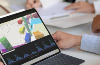
collaborate easily
Active Maps is designed to encourage and empower teams to collaborate, share and discuss the data visualisations, fostering a culture of trust and giving teams insight to make proactive business decisions.
golden thread
Active Maps doesn’t duplicate your data, it simple streams the data held in siloed software or sensor platforms into a single view, providing a single source of truth or golden thread of information.
team data access for improved decision making
Pulling the data that matters out of silos and making it accessible to everyone to view and analyse can lead to far greater insights. Empowering your team to use a tool like Active Maps can make change happen quicker. A more collaborative approach to your data insights fosters a greater understanding of business problems and therefore a better, more inclusive channel in which to develop the best solutions.
our clients
Dr Peter D. Hunter
Forth-ERA Science Director & Associate Professor of Earth Observation Scotland's International Environment Centre
The Forth-ERA projectis the primary force in Scotland’s bid to become a net-zero society, in developing a detailed understanding and analysis of the Firth of Forth we’re creating programmes that use nature toreverse climate change impact in our ecosystems and environment
Dr Peter D. Hunter
Forth-ERA Science Director & Associate Professor of Earth Observation Scotland's International Environment Centre
The team at 3DEO are experts in their field, working with us as experts in ours, we’ve developed a cutting edge digital estate for the Firth of Forth and become an exemplar for digital water in the process, the ability to visualise climate programme results on our Active Maps dashboard allows our successes to be easily digested by a wide target audience.
book your free demo
Choose to find out more about exactly how Active Maps can benefit your business with a no obligation 30 minute online demonstration tailored to your needs. Book a time and date that suits you below.